Upper Mantle Heterogeneity and Weak Subduction Boundaries Control Crustal Stress in the Korean Peninsula
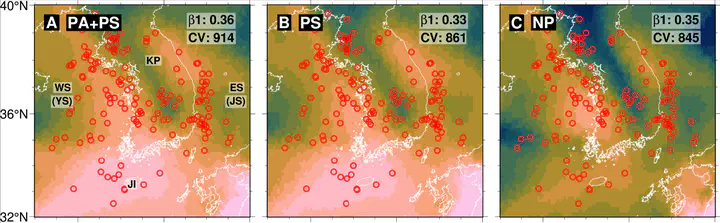 Spatial distribution of strain rate at a depth of 25 km in the Korean Peninsula for representative model cases: (a) PA + PS (base case), (b) PS-only, (c) no-boundary (NP) case. Red circles indicate the distribution of earthquakes with magnitudes ≥3.5 from the Korea Meteorological Administration catalog (1978–2024). Geographic references–KP: Korean Peninsula, WS: West Sea (YS: Yellow Sea), ES: East Sea (JS: Sea of Japan), and JI: Jeju Island.
Abstract
Most earthquakes occur at plate boundaries, but some also strike within stable continental interiors. Although dominant causes of such intraplate earthquakes remain elusive, a prevailing hypothesis attributes intraplate stress and seismicity to variations in lithospheric thickness. Here, we test this hypothesis using the Korean Peninsula as a natural laboratory by constructing three‐dimensional numerical models that extend from the surface to a depth of 650 km, incorporating realistic plate boundary configurations and deep thermal and compositional heterogeneities. Our results show that lithospheric thickness variations alone cannot account for the observed seismicity distribution and stress orientations. Instead, models that include weak subduction interfaces, slabs extending into the transition zone, and mantle buoyancy—while excluding shallow lithospheric density contrasts—explain the observed seismicity and stress distribution. In particular, the subducted Pacific slab in the mantle transition zone acts as a gravitational sinker, enhancing crustal compression along the eastern margin of the peninsula.